Morecambe Structure and the Two Hills Floodplain: History and Operation
Written by Heather J. Marshall
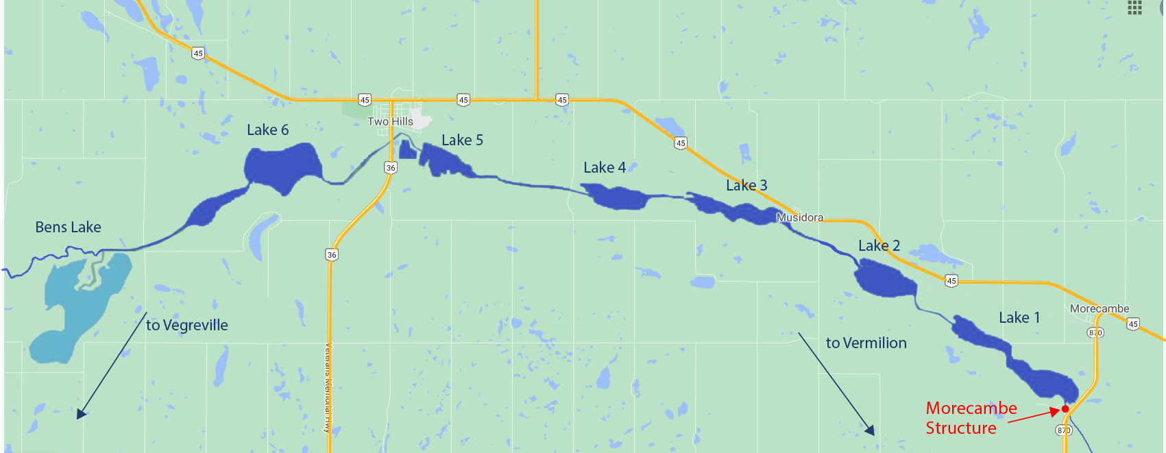
Above: Map of the Two Hills floodplain: The Vermilion River moves north from Vegreville before passing through a chain of 6 interconnected lakes, known as the Vermilion Lakes. (Watt Lake to northwest is not shown.) Image adapted from: googlemaps.ca
TWO HILLS FLOODPLAIN: FLAT + ALTERED = FLOODING
- Low, flat topography of floodplain and shallow depth of Vermilion Lakes limits drainage
- The elevation of the river only drops 1.6 cm per km as it moves through these lakes and water can take 7-10 days to travel less than 30 km
- Operations Infrastructure Manager of the Morecambe Structure, Carlin Soehn said the floodplain “is like pouring water onto a coffee table.”
- The Golder Report in 2009 said, “The NSWA has identified the Vermilion River Basin (VRB) basin as one of the most altered watersheds in the North Saskatchewan River Basin.”
- wetland drainage
- land-use changes (agriculture, municipal and industrial development)
HISTORY
WHY WAS THE STRUCTURE BUILT?
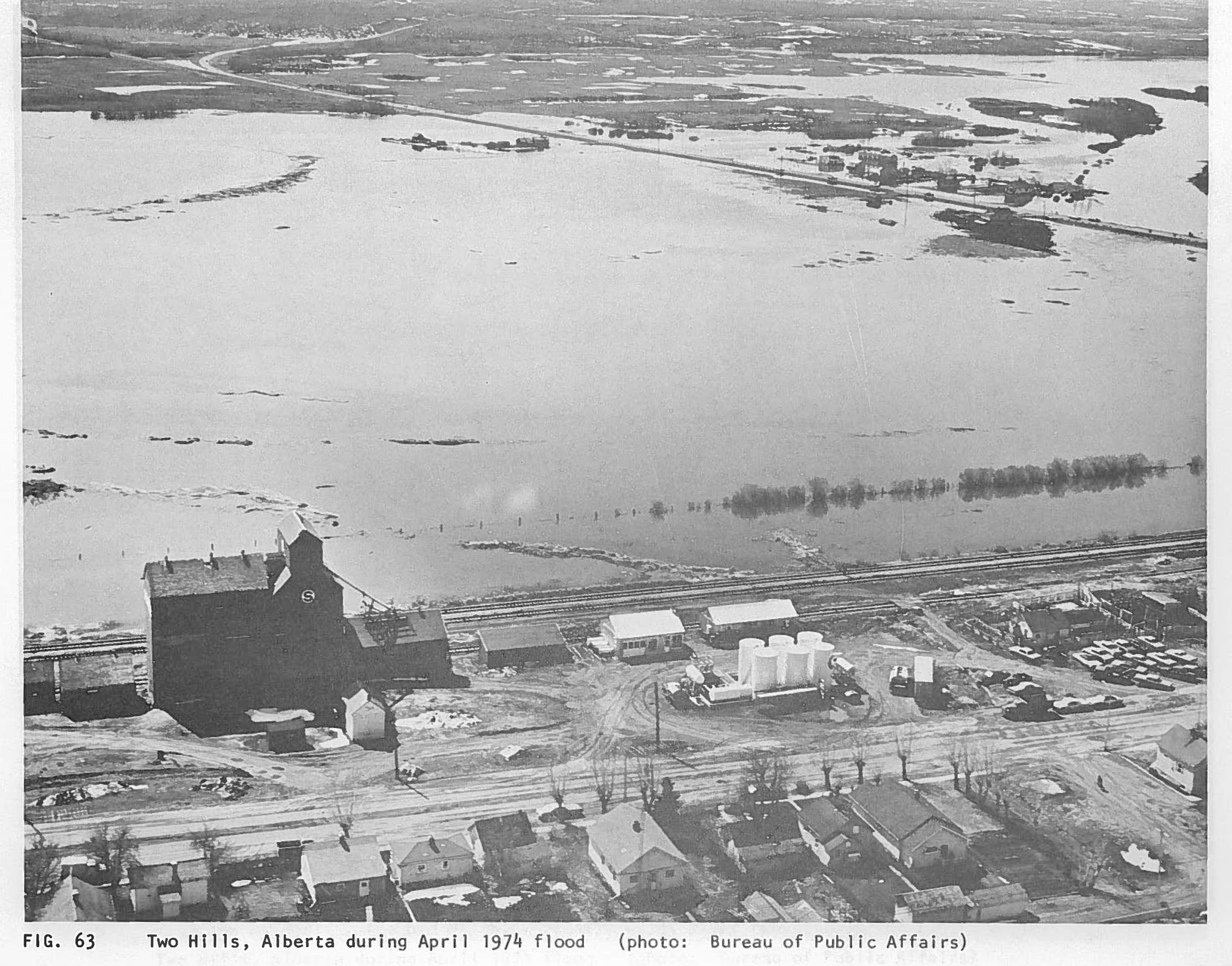
After heavy flooding in 1974, the provincial government asked for a study and report on the Vermilion River Basin. The Two Hills floodplain is the largest of the three Vermilion River floodplains and has the most acres flooded for the longest period of time. Image: History of Floods in the North Saskatchewan River Basin, Alberta Environment, 1981.
The 1974 Report showed:
- The main agricultural flood problem was identified as damage to native hay crops
- Runoff volume more of an issue than peak flows
- The Two Hills floodplain has a particularly difficult time draining off water after a flood
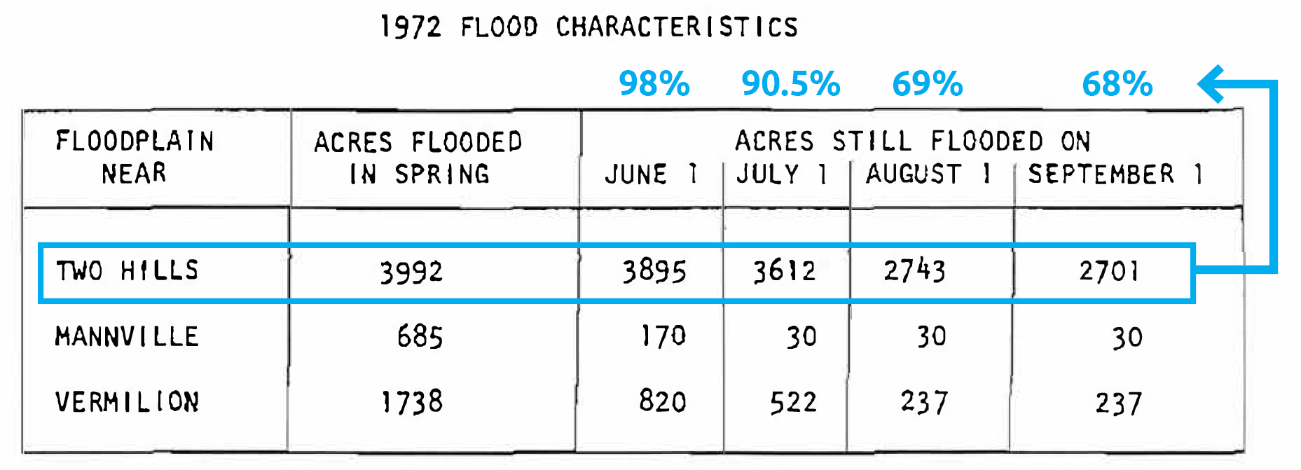
Difficult drainage: By July 1st, over 90% of the acres were still flooded in the Two Hills floodplain. Two-thirds of these remained flooded in early September. By contrast, less than 1/4 of the acres in Mannville floodplain were still flooded on June 1st, while the Vermilion floodplain had dropped to less than 1/2. Image adapted from: “Vermilion River Basin Study: A Summary Report” (Alberta Environment 1974).
2 key suggestions were implemented from the 1974 Report:
- Dredge, straighten and channelize Vermilion Lakes: Dig deeper and wider channels from Ben’s Lake to downstream of the Vermilion Lakes to improve flow and capacity between the lakes (1975-1978)
- Build a “flow control structure” just south of Morecambe: Construct structure adjacent to the natural outlet to provide more discharge capacity at the end of the chain of lakes (1976)
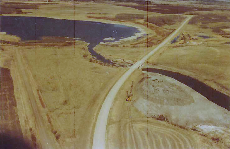
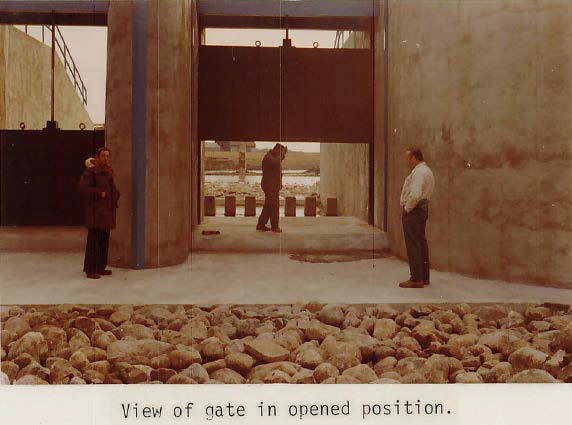
Natural outlet from Lake #1 before the Morecambe Structure was built. Image: 1976 Morecambe Structure Construction Report (AEP).
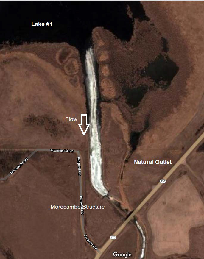
Google maps shows the natural outlet for Lake #1 (at right) and where the Morecambe Structure created a second outlet (at left) to allow for more drainage from the floodplain. Image: googlemaps.ca
DID YOU KNOW? The original Morecambe is an English city on the Irish Sea. The name is believed to either mean “a hollow or small valley near the sea” or “a curve of the sea”.
HOW DOES IT WORK?
- It’s the only infrastructure in the VR system that can be adapted (the others are fixed or static)
- It controls the flow with 3 operable overflow gates that open from the bottom up
- The gates are opened to “pre-release water” — draw the lake levels down (mainly before summer flooding) — and then to temper and reduce peak flows after the flood moves through the area
- It reduces peak flows both upstream and downstream
- The main benefit of the structure is before summer flooding begins
The Morecambe Structure was finished in 1976. The design was created to increase the outlet capacity of the floodplain, and release water well before the natural outlet allowed any water to pass. Image: 1976 Morecambe Structure Construction Report (AEP).
DID YOU KNOW? Spring flooding (which happens approximately every second year) is generally considered good for farmers, as long as the water has drained off the landscape by the beginning of June. It is often a second flood in the summer (less common) that is problematic — damage to native hay and a shorter growing season may not allow for two cuts of hay.
EARLY OPERATIONS (1976-1991):
- 1976-1987: With no operating plan in place, it is speculated that the operations were more beneficial for upstream landowners and at the cost of flooding downstream landowners
- 1987: An Operations Plan attempted to balance the flood benefits to both upstream and downstream landowners
- 1990 and 1991: Morecambe structure operations were blamed for flooding to downstream land owners and damage to hay crops
- 1991: The Morecambe Structure gates stopped operating
DID YOU KNOW? While spring flooding occurs about every second year along the Two Hills floodplain, summer flooding is less frequent. However, there have been summer floods for three of the past four years and 2018 was the third largest spring flood on record.
NO GATE OPERATIONS (1991-2005)
- 1991-2005: While the Morecambe Structure was not in operation, its fixed crest weir still allowed water to pass above the gates
- 1997: Bad flooding propelled the county to correspond with the provincial government to ask what could be done
- 1998-99: A committee was formed with stakeholders, municipalities and landholders to give input on the issue
- Stakeholders met twice every year to try to find common ground on how to operate the Structure
- 2000: VR Stakeholder Committee wrote a report with recommendations
- 2002: Vermilion River Operations Advisory Committee (VROAC) was created under ministerial order
- 2006: Operations Plan released by VROAC – is similar to the Op Plan written in 1987 – which tried to balance upstream and downstream landowners flood benefits. Has since been updated (e.g. changed spring operations from May 15th to an earlier start date of April 15th)
- 2006: The Morecambe Structure begins operating again
- 2010: Replaced 2 original gates to 3 variable sized gates to allow for more refined flow adjustments
- 2012: Changed date of opening gates from May 15th to April 15th
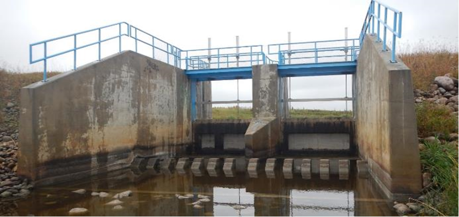
Looking upstream at the Morecambe Structure today. Three vertical lift gates open from the bottom below the fixed crest weir. Water is also able to pass over the fix crest weir above the gates. Image: AEP.
DID YOU KNOW? Morecambe Structure has minimal impact on peak flood levels at Bens Lake and Lake 6, and has no impact on Watt Lake.
CHALLENGES: AN IMPERFECT SOLUTION TO A COMPLEX PROBLEM
- Limits to the capacity of the shallow Vermilion Lakes, the Morecambe Structure, and the channels downstream of the structure
- The surrounding land is flat and that makes it difficult to contain water from spilling over into what are mostly native hay crops in the area
- Didn’t meet original expectations– 1974 Report said “It is important to recognize that this scheme would not provide total flood protection” — but rather, help mitigate flooding impacts (Environmental Planning Division)
- Channel improvement capacities were not able to meet the original design intent of project planning due to limitations such as low topography
- Alberta Environment is not allowed to use the structure to artificially release water downstream that would exceed bank capacity (i.e., they are responsible if the downstream area floods)
- On top of agricultural loss and damage, municipalities can spend thousands of dollars on road and bridge repairs
- The Morecambe Structure is better equipped to deal with smaller floods than larger-scale floods
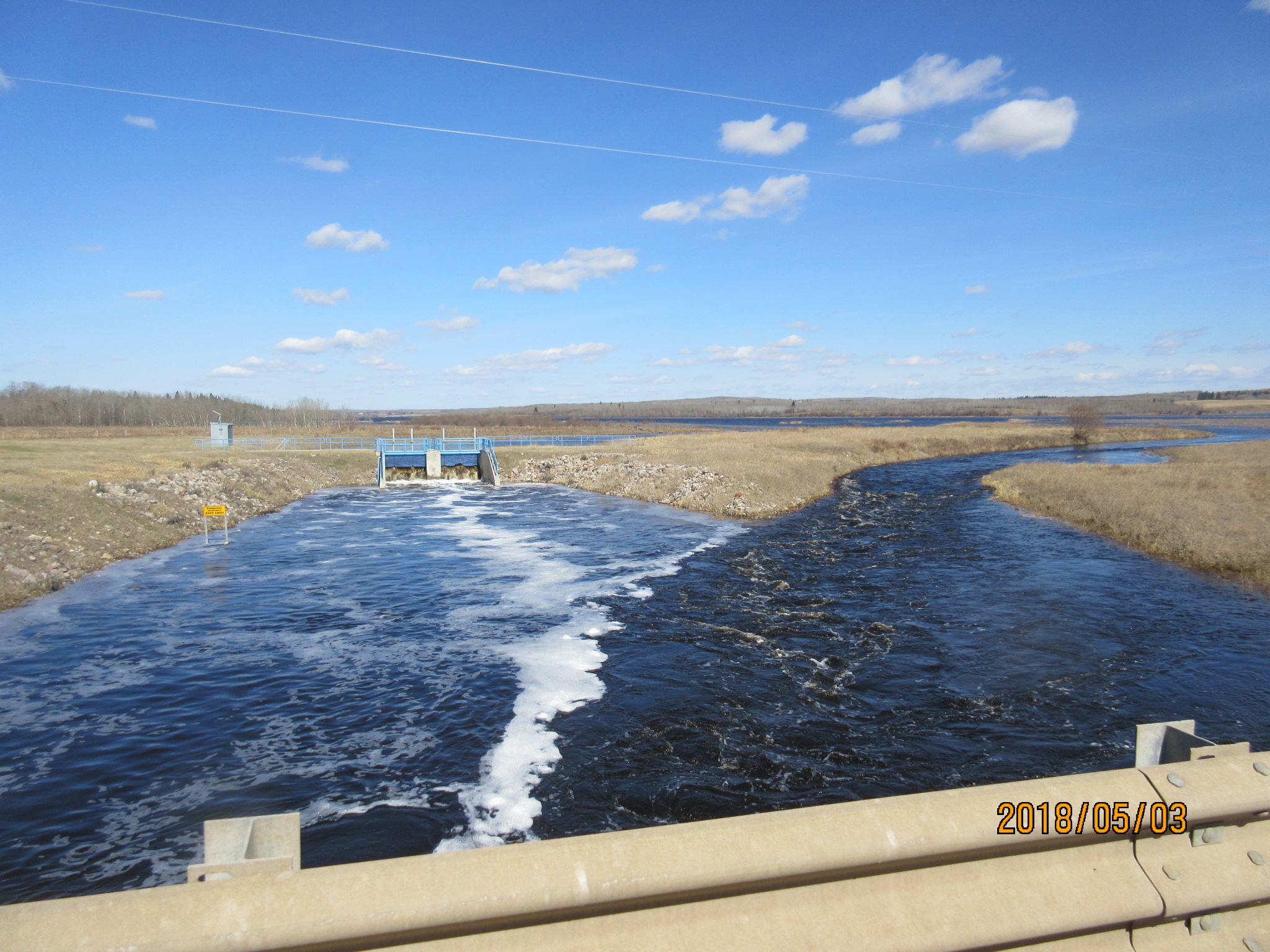
The Morecambe Structure (at left) flows joins the natural outlet (at right) during the 2018 spring flood. Image: AEP.
DID YOU KNOW? Water level data is collected at the Morecambe Structure’s station. To see its water data, go to https://rivers.alberta.ca/ and click on the magnifying glass and then type “Morecambe, Alberta” in the field. Move the page down to just below Morecambe, then click on the black icon with waves that says “Vermilion Lake Near Morecambe”. This will give you current water levels and annual trend data for this station.
CONCLUSIONS
- The Project Infrastructure provides better flood protection benefits than natural conditions, regardless of operations
- The Structure’s current operations result in a shorter flooding duration (earlier flood end date) than would occur under natural conditions (5 to 7 days depending on event)
- Morecambe Structure Operating Plan attempts to balance flood benefits to upstream and downstream stakeholders
Special thanks to Carlin Soehn, who is the Operations Infrastructure Manager (Water Infrastructure and Operations Branch – Alberta Environment and Parks) of the Morecambe Structure for his input, photos, and expertise.

Heather J. Marshall is a freelance writer and graphic designer. Her main interests are local food and history, human connection to the environment, and biographical stories. To contact Heather, please go to: hmmcreate.myportfolio.com